Landscape architecture: There’s an app for that
Smartphone applications are greatly affecting the way we live, interact, collect and share data, whether at home, in the office or anywhere in between. A growing number of landscape architects now use apps in their workplace. In a recent survey by the American Society of Landscape Architects, 76% of respondents use apps in analysing a site, 44% use apps for conceptualising their ideas and 50% use landscape apps during construction. While there are no specific figures yet in the Gulf region, at desert INK we have started incorporating apps in our work processes. We’ve compiled some of the most useful tools and apps for landscape architects, to show where we think the industry might be heading in the near future.
Site analysis
Commencement of every project requires landscape architects to study and make inventory of the site. Before, armed with a pen, a notebook and a digital camera, a landscape architect wrote and sketched his observations.
Today, with the help of smartphone apps, landscape architects can make their site inventories quicker and more accurate. Technical assessments can be made with applications such as Clinometer (an app that measures the angle and percentage of the slope) or Sunseeker (which uses GPS and magnetometer to trace the path of the sun). Planimeter measures land area and distance on a map, while Soil Web provides access to USDA-NRCS soil survey data. These apps all help landscape architects get necessary data faster rather than relying on the client’s information.
Google Earth and Street View and camera applications like PhotoSynth can be used to visualise the site. In our office, we often use Google Earth, and sometimes Street View, to locate existing trees and understand built structures. Another great help for us is Sunseeker, as it helps us to plan spaces better – say a pool or a lawn that needs to maximise the amount of sunlight, or to position a structure so that it receives less light.
The accuracy of these apps is still being developed and most are limited to US-based data, but the fact that they are now available has the potential to make our work more efficient. In the future, if they can be calibrated to ensure accuracy, it will be a great assistance to landscape architects as well as saving time – a saving which can shorten overall project delivery or delivery to the client.
Plant identification
Botanical and horticultural knowledge is of great importance to landscape architects. Books are a good place to start when identifying and selecting plants, but leafing through pages and pages of different plants can be tiring and inefficient. Enter the apps that help identify plants easily. LeafSnap, developed by Columbia University, the University of Maryland and the Smithsonian Institution, uses visual recognition software to help identify tree species through photographs of leaves. The app is still geographically limited to the US, but this great initiative will be replicated across the world. An online database of trees and shrubs of various regions will help improve knowledge of a site, which ultimately improves design capabilities.
Design concept
Conceptualising design involves A LOT of paperwork. By paperwork, I mean countless reams of tracing paper, design drafts and sketches. Smart apps that allow us to sketch on screen and save them in digital format is a great way to create ideas, collaborate and save paper. Digital sketchbook apps like Autodesk Sketchbook and Morpholio Trace are good apps for concept visualisation. The Autodesk app has a wide range of brushes and a colour palette that lets designers create anything from simple sketches to full-blown presentation drawings.
We’ve started using Sketchbook, and it has helped us create sketches that are presentable for a concept submittal. Morpholio Trace is a similar app for sketching and commenting over a drawing or photograph. As with other design disciplines, landscape design involves a lot of feedback and this app is fantastic for creating mark-ups quickly and exchanging feedback.
Renderings also help with concept presentations, as they portray the design intent realistically. While not strictly an app, various software helps landscape rendering become more realistic, like Lumion, which has a database of plants that is particularly useful for landscape architects. We’ve used Lumion a lot in our presentations, and it has certainly raised the game for us in presenting our ideas.
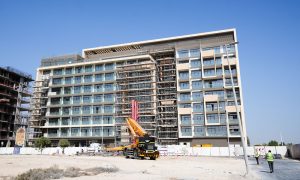
Construction
Timing, programming, scheduling and data organisation is important during construction. Topping the list of the construction apps is Aconex mobile, which enables contractors to access and capture important project information on-site. Contractors can share videos, images and project documents, send marked-up documents to other project team members and store records for offline access. Another useful tool for contractors is iScape, which lets you preview the hardscape and softscape installation prior to commencing work. It helps the client and the designer visualise the end result of every material option on-site, before any physical work starts.
These apps are just some of the up-and-coming tools that could revolutionise the way landscape architects deal with their work. As the technology becomes more and more responsive to our needs and information becomes more readily available, they will surely make our work faster, better and more efficient.
Kenneth Seraspi is a landscape architect at Desert INK.